x


South Asian weather is becoming increasingly difficult to forecast as monsoons grow more erratic — and global warming is raising the risks posed by violent rain storms.
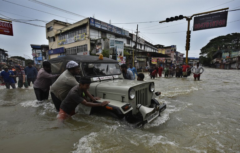
Intense monsoonal rains caused catastrophic flooding in Kerala, India, during August 2018. Credit: Raj K Raj/Hindustan Times/Getty
Western Ghats, Kerala
The rains did not let up all summer in 2018. By 14 August, most reservoirs had filled up and the people had grown weary of the monsoon. That day, Eby Emmanuel’s phone started buzzing repeatedly with messages from neighbours warning that the Meenachil River was overflowing. He realized areas downhill could flood in hours, endangering a hamlet of 90 poor families living on the sandy riverbank.
Emmanuel, the secretary of the Meenachil River Protection Council in Kidangoor, a collective of local river conservationists, quickly organized with other community workers and the Kottayam fire department to evacuate the people. But one resident, T. Raju, refused to abandon his belongings. He lay down on his stringed bed frame, figuring he had seen plenty of bad rains. Then, his bed moved and his television floated by. This wasn’t normal.
Raju jumped up, grabbed some clothes and 270 rupees (US$3.30) and fled to the evacuation site, he recalled in an interview with Nature last October. The water filled his home during the 2018 flood, Raju said, pointing to a water stain about 1.5 metres up his wall.
The state of Kerala, where the Meenachil River is located, received 164% more rainfall1 than normal that August, triggering what residents call the Pralayam — a flood to end the Universe in the Hindu religion. It was the biggest in the state since 1924. More than 400 people died, more than one million were displaced and damages amounted to US$4.25 billion, according to an Indian government report2.
Since 2018, “the sound of the rain beginning really disturbs my mood,” says Emmanuel. “It is not like before — we were sleeping peacefully even when it’s raining all season. But not any more.”

Eby Emmanuel is secretary of the Meenachil River Protection Council in Kidangoor, and runs the flood early-warning system there.Credit: Gayathri Vaidyanathan
The extreme rains of 2018 spurred Emmanuel and a team of community members to create an early-warning system for floods — a project that is unusual in South Asia because it was developed and funded by local residents, say researchers who have advised on the effort. It consists of a network of improvised rain and river gauges along the 75-kilometre Meenachil River. Schoolchildren, teachers and other residents take measurements daily, and even hourly during a storm. Using their knowledge of the local conditions and a growing data set, Emmanuel and his team issue flood alerts through community groups on the messaging service WhatsApp, and have earned widespread recognition for their efforts.
It’s a system that the India Meteorological Department (IMD) simply cannot compete with — for now — because it is difficult to issue flood warnings at such local scales, say researchers. In terms of early warnings, “we will need to wait for that golden period somewhere in the far future”, says Roxy Koll, a climate scientist at the Indian Institute of Tropical Meteorology in Pune, who is the scientific adviser for the community group.
There is a growing need for these kinds of warning system as the pace of climate change picks up. Throughout South Asia, natural weather disasters are occurring more frequently and with greater intensity — which some researchers link to alterations in the monsoon, changes to the natural landscape and global warming. This area is home to almost one-quarter of the global population, with 60% of people there relying on farming and living close to the land. That makes them especially vulnerable to climate change.
“South Asia is like a poster child for climate change,” says Koll. “Even as a climate scientist, I cannot imagine the impacts that South Asia would see. We are not prepared for the events that we already have.”
There has been a surge of bad news in the region over the past year. During March and April, a heatwave gripped India and Pakistan, killing at least 90 people and destroying wheat crops, which exacerbated a worldwide shortage of grain caused by the war in Ukraine. May saw landslides, floods and heavy downpours in northeast India. The monsoon arrived in June and there was widespread flooding, from Afghanistan to Sri Lanka. August spelled doom for Pakistan, when the nation was flooded after weeks of intense rainfall. More than 1,500 people died and damages exceeded $30 billion.

These girls were the first to create a rough river-height gauge on the Meenachil River after the 2018 floods.Credit: Gayathri Vaidyanathan
Scientists are racing to improve their forecasts and early-warning systems, especially for rainfall-related catastrophes, which cause the most loss of life in the region. It is a challenge because tropical weather is inherently more fickle than conditions in the mid-latitudes, where the wealthiest nations are located. And weather forecasting models were not originally designed for this part of the globe. What’s more, heavy rainfall and storms are related to the South Asian summer monsoon, a notoriously complex weather phenomenon. The situation has become even more complicated because climate change and urban development have changed the risks and even altered the behaviour of weather.
“In the tropical region, this problem of predictability is there, everywhere,” says K. S. Hosalikar, head of climate research and services at the IMD in Pune. “And climate change is adding fury to it.”
Every June, South Asia nervously awaits the summer monsoon, also called the southwest monsoon, which decides the fortunes of hundreds of millions of people. As the Northern Hemisphere tilts closer to the Sun during May, the land heats up and the warm air above it rises. The trade winds reverse course and flow in from the Arabian Sea, pushing moisture-laden rain clouds up the towering Western Ghats mountain range in Kerala and nearby parts of southwest India, triggering rain.
Within days, the winds find gaps in the topography of the Western Ghats and take rain across the subcontinent. By the time the monsoon ends in India, usually in September, it will have dumped an average of 850 millimetres of rain — more than three-quarters of the country’s annual total.
Scientists have noticed that the monsoon has become erratic over the past seven decades, with a propensity towards extreme rainfall and sudden droughts. Koll says this is caused, in part, by a supercharged Indian Ocean, which has warmed by 1.4 °C since 1870, more than other oceans3. There are frequent marine heatwaves that cause extreme rises in ocean temperatures, he says. And the trade winds seem to have weakened.
“Extreme weather events are responding to this huge change, because the oceans are a reservoir of continuous heat that supports all these weather systems,” Koll says. “To a large extent, most extreme weather events — particularly extreme rains, even droughts over land and cyclones — are tied to the Indian Ocean.”
Researchers don’t yet fully understand how changes in the ocean and the winds affect the monsoon and, by extension, local weather. But they have seen that the rains are not the same as they were 70 years ago. By 2015, the amount of rain falling over India had declined by about 6% from 1951 levels3. Droughts are now more frequent and widespread. There are prolonged dry spells and more intense wet spells4. And extreme rainfall events, which dump more than 150 millimetres in a single day, became nearly twice as frequent between 1951 and 2022 (see ‘Severe storms’). Widespread extreme downpours have tripled in frequency since 1950 over central India, where about 500 million people live5.
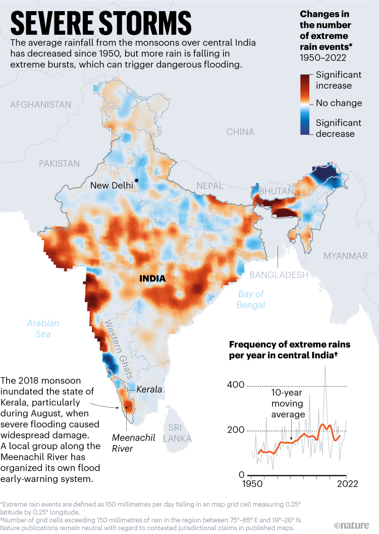
Source: Ref. 5; Additional data for 2015–22 from M. K. Roxy
Last year, 95% of India’s extreme weather deaths resulted from thunderstorms, lightning and heavy rainfall, according to government data (see go.nature.com/3jmkrt3). The rains are no longer predictable. In the worst cases, clouds can grow rapidly and deposit more than 100 millimetres of rainfall in an hour over a single neighbourhood.
Tropical rain and thunderstorms, and their impacts, are difficult to forecast sufficiently in advance, particularly at the scale of neighbourhoods or towns. And communicating forecasts is challenging, because many of the two billion people in South Asia live in remote villages and do not receive news alerts.
“We have a wide spectrum of users,” says Soma Sen Roy, an atmospheric scientist at the IMD in New Delhi. “We have people who are advanced at handling mobiles or computers. And there are people who have never seen a computer or mobile in their life.”
Kerala is a sliver of land between the Arabian Sea and the towering Western Ghats, where the monsoon first makes landfall. In August 2018, strong trade winds crashed against the Ghats and climbed over the mountains. Immense clouds, fuelled by bands of moisture from the sea, clustered and swirled against the range. Some grew as high as 15 kilometres. The weather system covered nearly the entire state and remained locked there by distant events, including a typhoon in the South China Sea.
Across the world, more than half of all annual tropical rainfall is caused by such widespread systems of clouds — spanning hundreds of square kilometres or more — that spring up when hot air carrying moisture rises and cools at high altitudes6. Such ‘mesoscale’ systems of thunderstorms can grow quickly in the tropics, and their development is difficult to spot on patchy meteorological networks. And because scientists are still learning how they grow, their behaviour and impacts are difficult to forecast in advance. In 2019, similar mesoscale systems dropped 50 millimetres of rain within two hours in Kerala, leading to flash floods and landslides.

A flood gauge along the Meenachil River.Credit: Gayathri Vaidyanathan
Farther north, close to the Himalayas, individual thunderstorms called cloudbursts can drop more than 100 millimetres of rain in less than an hour, accompanied by strong winds and lightning, over areas of up to 30 square kilometres7. Very little is known about these cloudburst events. “Climate change is making [extreme rainfall] more erratic and the weather forecasting models are unable to account for that increase in chaos,” Koll says. “It is a challenge in the tropics.”
The IMD can forecast some of these rainfall events with about 70% accuracy two days before they happen. But the accuracy drops to 60% for forecasts 5 days ahead, and its 10-day forecasts are even less accurate, it says.
“The monsoons are one of the hardest natural processes to be understood,” says Arpita Mondal, a climate scientist at the Indian Institute of Technology Bombay. Add to that the unpredictability of mesoscale convective storms, and long-range forecasting in this region becomes even more challenging, says Vimal Mishra, a climate scientist at the Indian Institute of Technology Gandhinagar.
Forecasting storms before they develop requires a dense array of observation stations, which does not exist in the region. The IMD has the best set-up in South Asia, and it gets data from 33 doppler weather radars, 56 balloon-launching sites, 25 lightning-detection sensors and 725 automatic weather stations, as well as meteorological satellites, ships and other sources. The Indian government and agencies such as the US National Oceanic and Atmospheric Administration also operate observation buoys on the Indian Ocean.
But only some of these data are shared or used in monsoon forecasts, Koll says. “Data ideally should be available in the open domain so that we can use it for cutting-edge research.” He adds that the IMD sometimes releases data when requested, but the process is slow and it doesn’t provide all data. The IMD’s Hosalikar responds that data are freely available for researchers, except for commercial purposes.

Climate scientist Roxy Koll studies extreme rains and advises the Meenachil River Protection Council.Credit: Gayathri Vaidyanathan
The observations feed into the Global Forecast System, developed by the US National Centers for Environmental Prediction, which the IMD has tailored to local conditions. But models created in the United States and Europe do not account for how much South Asia’s unique farming practices and dense population can change the weather, says Mondal. Forecasting “becomes unimaginably complex because there is a blurred line between human and natural systems”, she says.
Every year before the monsoon, millions of smallholder farmers on the Indo-Gangetic Plain turn on pump sets and flood their rice fields during the dry season. The weather forecasting models predict that evaporation of this irrigation water should cool the land surface and ease heatwaves. But Mondal and her colleagues found that existing forecast models overestimate the cooling by almost five times8. “There’s so much happening at the local scale, which is also hard to measure and predict,” she says. “That is creating this gap of what is being predicted and what is actually happening on the ground.”
Indian meteorologists run the models twice a day at a 12-kilometre resolution to generate weekly forecasts. That’s too coarse to be able to forecast convective storms, which need a resolution finer than 4 kilometres, says Thara Prabhakaran, a cloud scientist at the Indian Institute of Tropical Meteorology. She studies the formation of such storms using data obtained by aircraft, fitted with lasers and other instruments, that fly through rain clouds to measure droplets and aerosols. The hope is that these data can improve forecasting models. “Nowadays, there are very heavy rains happening in a short period of time,” she says. “How does it happen? What are the physics in the model that we are missing?”
Acknowledging the inherent difficulties of the problem, the IMD has focused since 2017 on issuing short-range warnings called nowcasts ahead of thunderstorms in major cities. These use cloud and wind data from radar, and a 3-kilometre-resolution model to issue forecasts that are accurate, on average, 80% of the time, according to the IMD. But Hosalikar acknowledges that even this isn’t good enough. India’s megacities are complex environments containing highways, crooked lanes, skyscrapers, slums and quick changes of elevation. The urban structures channel winds and create pockets of instability, meaning it can rain hard in one neighbourhood while the next one over remains dry. “We should use a 600-metre model,” Hosalikar says. But that is impractical without more data and improved models.
False alarms for short-range forecasts, within 48 hours, can be as high as 40% in some regions, Mondal says. With that kind of uncertainty, a reservoir operator might decide not to open the sluice gates of a dam, leading to catastrophic flooding, according to some researchers. Deaths from extreme rainfall and storms have not declined in recent years, even with the IMD’s nowcasts, says Sen Roy.
Before the 1990s, when people farmed the Meenachil River watershed, floods were welcome. During every monsoon, the river would flow predictably into paddy fields and fertilize them with silt. Children would fashion canoes out of banana-tree trunks and row them down streets. When 75-year-old retired teacher Elizabeth Koshy bought land in these rain-prone hills, she chose an elevated patch that wouldn’t flood.
But people have changed how the water flows downhill. Villas have been built on paddy fields that once absorbed water, irrigation canals have become roads and the riverbed has been mined for sand. In 2018, for the first time, Koshy’s home flooded.
“If rain is there for one day all over Kerala, the entire Kerala is flooded. Not because there is more water, but because the water has no way to flow easily,” says S. Ramachandran, president of the Meenachil River Protection Council.
Flooding and droughts happen when the local water cycle is overwhelmed because of changes in how people use the land, and sometimes because reservoir managers make the wrong decisions as a result of imprecise forecasts, says Mondal.
The human element in extreme weather risk makes it challenging for meteorologists to issue granular ‘impact-based forecasts’ that warn people about events such as flooding, lightning strikes and landslides in their immediate vicinity. That’s why Emmanuel and his community on the Meenachil River decided to take matters into their own hands. “We are not following the IMD,” Emmanuel says, referring to government forecasts. “We are depending on our trusted volunteers’ reporting.”

Students use rain gauges to take daily measurements of precipitation along the Meenachil River.Credit: Gayathri Vaidyanathan
On a beautiful day a week after last summer’s monsoon ended, Emmanuel walked into the courtyard at St Joseph’s Upper Primary School in Malayinchippara, where he was greeted by the deafening sound of a marching band. This is one of 220 outposts where Emmanuel has set up rain- and river-monitoring gauges. He says the visit is meant to motivate his volunteers, but the students already take this effort seriously. Job Jose, aged 10, says a landslide demolished his neighbour’s house and his family lost their well. Meera Binoy, who is 11, saw flood waters enter her house and damage some stored timber. Speaking in Malayalam, “A cloud burst open,” she says, alluding to a convective storm.
The schoolchildren log daily rainfall and river-flow measurements in their rain book and send the data by WhatsApp to a group that oversees the operation. In a nearby village, 70-year-old retired bank manager P. C. Jose collates the data. He is part of a team that analyses the readings from 220 river gauges and 13 rain gauges spread across the 1,272-square-kilometre watershed. When there’s no rain, measurements are taken once a day. During the rains, the team increases the frequency to once an hour or more.
Emmanuel and his team have deep knowledge of the surrounding topography and, aided by the data, are able to predict when areas downhill will flood. It’s not yet entirely scientific, but it works, says Emmanuel. The group is collaborating with Koll, whose family hails from this area, to ensure scientifically rigorous data collection through an online portal so they can automate forecasts in the future.
This effort is “the best working example” of grassroots action, says Koll, which is something that the United Nations’ Intergovernmental Panel on Climate Change has called on local communities to do to adapt to climate change. The early-warning system along the Meenachil River “can be tailored for climate action across similar environments across South Asia that face similar climate challenges and land–river use changes”, adds Koll.
As well as producing finer-resolution flood forecasts than the IMD does, the local early-warning system reaches people through trusted networks. Koshy, the retired teacher, relies solely on the alerts from the group every monsoon, she says. “If I don’t get correct information, I’ll be in trouble because I cannot remain in this house if it gets flooded.”
A few months after the 2018 floods, Koshy had a top floor built on her house, along with a ramp to accommodate her wheelchair. Others in her village have also built upwards in response to flooding, she says.
After visiting his volunteers all day, Emmanuel took a break in an office he shares with another community group. He pointed at a traditional lunar calendar hanging on a wall. Farmers use it to plan their planting and harvesting schedule, but these days, nature’s rhythm is wonky: there is less constant rainfall, and more unpredictable fury. The early-warning system is sorely needed, he says. But keeping volunteers on track, recruiting new members, ensuring data collection, getting buy-in from local officials and securing funding for gauges all take up a lot of his time. Emmanuel is committed to the community because his ancestors were elected leaders and social workers here; it’s his family’s legacy.